San Francisco map poster — free & printable
San Francisco's surveyors drew a grid and then refused to negotiate with the terrain, so streets run dead straight over hills steep enough to need stairs. The result is a map that looks flat and orderly while describing some of the most vertical ground of any American city — and it contains one of the great urban seams anywhere.
United States · centred near 37.7749° N, 122.4194° W
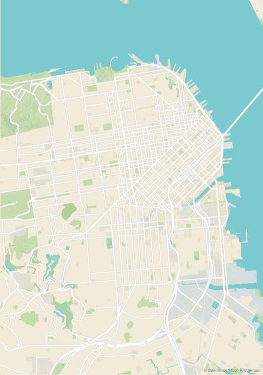
The Market Street seam
Market Street runs southwest from the Ferry Building on a diagonal, and the grids either side of it were laid out on different axes. North of Market the blocks are small and aligned one way; south of Market they are much larger and rotated. Where the two meet along Market itself, streets hit at odd angles and leave triangular blocks. It is the most distinctive single feature on the map and worth framing deliberately.
Water on three sides, park across the west
The city occupies the tip of a peninsula, so the bay wraps the north and east and the Pacific closes the west. Golden Gate Park adds a long green rectangle running almost the full width of the western half — an unusually rigid shape for a park, because it too was laid out to the grid. Between the water and the park, a San Francisco crop has strong edges on every side.
The grid that gives up
In a few places the terrain wins. Twin Peaks, Mount Sutro and the slopes above the Castro break into curving contour-following streets, and the Presidio abandons the grid entirely. These pockets of irregularity are where a poster gets its interest — a crop of pure grid reads as wallpaper, but a crop that catches the moment the grid bends does not.
Where to centre a San Francisco poster
- Mission
- South of Market's larger blocks, with the grid at its most regular and the flattest ground in the city.
- North Beach
- Wedged between Telegraph and Russian Hill, where the grid starts to distort around the slopes.
- Haight-Ashbury
- Sits against the eastern end of Golden Gate Park, so the park edge anchors the frame.
- Sunset
- The most relentless grid in the city, running in even rows all the way to the ocean.
- Castro
- Where the street pattern begins to break against the hills above it.
- Russian Hill
- Includes the Lombard switchbacks, the one place the map shows the gradient outright.
Why Blush suits San Francisco
Blush gives San Francisco a warmth that matches the light rather than the architecture, and the soft ground stops a city made almost entirely of straight lines from reading as clinical. It also keeps the bay and the Pacific from overwhelming three edges of the frame, which is what happens in the cooler palettes. Porcelain is the restrained alternative; Plotter suits the grid if you want it to look surveyed.
Printing and framing San Francisco
The city is close to square — roughly seven miles by seven — so a square frame fits it better than either portrait or landscape, and wastes the least paper on open water. If you would rather keep a standard size, portrait A2 works if you accept cropping the Sunset, since most of the visual interest sits in the northeastern quarter.
Every export is drawn at your chosen paper size rather than upscaled from a screenshot. See the full printing guide for sizes, DPI, bleed and crop marks.
San Francisco map poster questions
Can I include the Golden Gate Bridge?
Yes, but it sits at the far northwestern corner, so keeping it in frame pushes the city centre down and to the right. Zooming out to around 11.5 holds the bridge, the Presidio and downtown together — at the cost of the street detail in the Mission and the Sunset.
Why does my San Francisco map look so flat?
Because the streets genuinely are laid out as though the hills were not there. The gradient shows up indirectly — in the switchbacks on Russian Hill, the broken grid around Twin Peaks, and the stair-steps in the Castro. Framing those areas is the only way the terrain appears.
Can I make a poster of Oakland or Berkeley instead?
Yes, and the East Bay looks quite different — the grid there follows the shoreline and then tilts to run up into the hills, so it curves in a way San Francisco's never does. Search either city directly, or zoom out to catch the whole bay and both sides of it.